Final Project - Contrasting River Styles
The core of your final project will be to read riverscapes in three to four contrasting reaches in a watershed of your choosing (other than the Logan River) and to properly characterize them. You will use the interpretive skills you have developed all semester long, and those four “steps” to reading riverscapes identified in Chapter 1.
 The riverscapes you choose should each be long enough in length to be representative (e.g., typically 500 m to 2000 m depending on size of system). The riverscapes should be somewhere you have visited in person or (ideally) can visit in person to complete the assignment. The selection of riverscapes reaches, should collectively satisfy the following criterions:
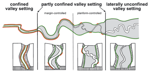
- At least one confined riverscape
- At least one partly-confined riverscape
- At least one laterally unconfined riverscape
- All in one watershed and preferably along same water course (e.g., like our field trip on the Logan River where we stopped at five locations along the way)
As always, you will be preparing a web page (or series of nested sub-pages) on your class website for the assignment. As we unpack expectations for how to complete this assignment, I will post them here.
What should my Final Project Page(s) Include?
I expect your web page for the final project to be logically organized, inviting and engaging. It should have clear heading and subheadings for easy and logical navigation and cross referencing. It should have figures, tables and/or interactive maps as appropriate to illustrate key concepts and findings, or report your work. All such figures and tables should have numbered captions, with adequate descriptions. You should have adequate text explaining each piece of the project. If easier for you, you may choose to break up the project into sub-pages, but if you do so please provide easy and logical navigation (e.g., hyperlinks, buttons, etc.) between pages. Finally, make sure to properly cite your sources.
A Introduction to Your Study Watershed
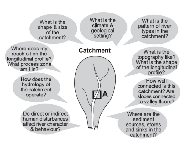
 Start with an introduction to the watershed/catchment that contains the three (or more) riverscapes you chose to read. Think back to the Module 3 Catchment Assignment, and how you described the Logan River. This could be as little as one section with a few paragraphs, a figure or two and a table, or could be more elaborate.
You should aim to minimally answer the following questions in this section:
- Location - Where in the world is the watershed and in relationship to other larger basins it may be tributary to? Where does this watershed eventually drain to?
- Location of specific riverscape reaches therein (e.g. a catchment map with locations denoted of study reaches)
- What is the climate?
- What is the flow regime?
- What is the geologic setting?
- What is the physiographic setting? A map of landscape units (e.g., US EPA Ecoregions) and how they intersect the drainage network would be helpful.
- What are the dominant vegetation communities and their distribution in the watershed (e.g., forests, grasslands, rangelands, crops, developed, etc.)?
- What is the shape & size of the catchment? You may choose to report some of the simpler catchment morphometrics for your watershed (from Chapter 3).
- What is the mainstem length of the major river in your watershed?
What should I do at each site?
At each site, you should provide a complete reading of the riverscape. Recall the steps from Chapter One. You might start by identifying what landforms are present and addressing the questions below:
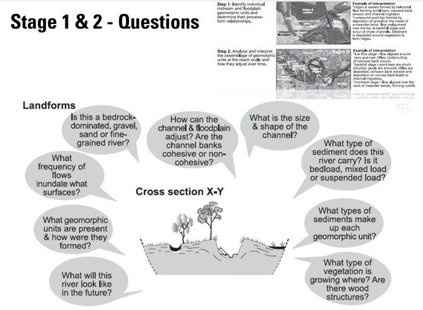
Once you have addressed those questions, you should think about synthesizing your observations at the reach scale, by addressing the following questions:
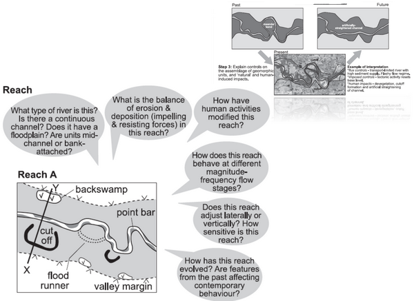
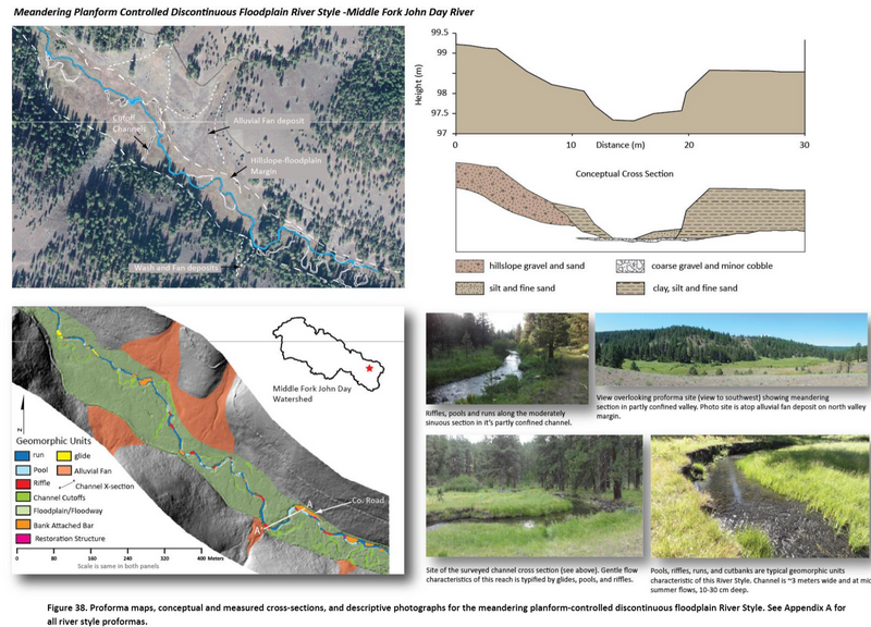
In the River Styles Framework, many of these “site” or “reach-scale” insights are cataloged with proformas and a fairly standard set of figures are used to illustrate your observations and interpretations. Some of the types of figures you should consider for each site include tier 1, geomorphic unit maps (i.e., valley bottom, active channel, active floodplain, inactive floodplain), in channel geomorphic unit maps, representative conceptual cross sections, annotated photographs. Some examples are shown below from the O’Brien et al. (2015) Middle Fork John Day Report:
What should I do to intercompare each site?
Once you have analyzed all your sites, it is time to put them in their catchment context. This is simplest to do as a collective intercomparison across each of your sites. Recall that in ‘reading the riverscape’, this is step four:
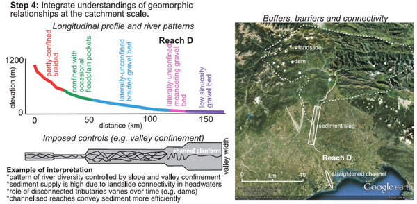
Therein, you should be attempting to answer the following questions and comparing and contrasting how the answers vary between your sites:
FAQ
- Do I have to stick to three sites?
You can always opt to include more sites, and I encourage you to as it will allow you to better explore the diversity of the river system you chose. If you do, you can provide a much more limited coverage of those sites.
- Do I have to use GIS or specific software to complete this assignment?
Throughout the semester, we have emphasized that there are a lot of ways to get answers, create maps and quantify things. Some of you may be proficient, efficient and comfortable producing all your maps in ArcGIS or QGIS. That’s fine, but not expected. Some may do their maps in webGIS platforms like Google Maps, the USGS National Map, Google Earth, GeoJSON, or CalTopo. Many of you may do field sketches, or sketches on top of basemaps or screenshots from the maps above in things like PowerPoint, FastStone Capture, SktechPad, AutoDraw, Inkscape or a plethora of other programs. You can also really effectively do these maps and figures by hand and scan your figures. I don’t care what you use. You can make cartographically effective and useful maps in each, as well as confusing an ineffective maps in each.
Post your questions on the discussion board!
Relevant Papers
Brierley & Fryirs (2005) River Styles Framework
 The River Styles Framework is laid out in Part 2 of the Brierley and Fryirs (2005) book and is the conceptual basis for much of our book. For an overview lecture of the framework, see this Module in WATS 6860 Ecohydraulics.
- Brierley, G., and K. Fryirs 2005. Geomorphology and River Management: Applications of the River Styles Framework. Blackwell Publishing, Victoria, Australia.