Syllabai
Catalog Description
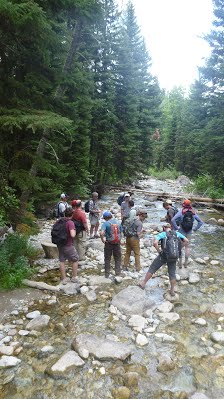
Introduction to fluvial geomorphology through the reading of landscapes and riverscapes. Students learn an appreciation of riverscape diversity and how fluvial processes shape landscape form and character. Self-led field trips (in riverscapes of student's choosing) are required.
| Semester(s) Traditionally Offered | Spring |
|---|---|
| Credits: | 3.000 Credit hours Matriculated (4.5 CEUs) |
| Levels: | Graduate, Undergraduate |
| Schedule Types: | Online Asynchronous |
| Cross-Listed As: | Spring 2026: WATS 6900 & CEWA 6900; Proposed Spring 2027 WATS 6155 CEWA 6155 |
| Pre-requisites | None |
Individaul Schedule & Syllabai
This course is typically taught every Spring online (pending adequate demand).
Spring 2026
Schedule & Syllabus
Past Versions
This class was previously delivered by Professsor Wheaton as hybrid (in person and online synchronous) as WATS/GEO/CEWA 5150/6150. That class is still be offerred but switching to in person only delivery and being taught in Fall 2026 by Professor Julianne Scarmado.
Past versions of the course give an idea of the schedule, syllabus and work the previous cohorts of students undertook.
Past Versions
Spring 2021
Schedule & Syllabus
Spring 2022
Schedule & Syllabus
Spring 2024
Schedule & Syllabus
Spring 2025
Schedule & Syllabus
Fees
Fees were removed from this course.
- USU Students - Regular tuition is charged on a per credit basis for USU students.
- Non-USU Students - $1049.95 for Spring 2026 (see at CEU Checkout)
Course Objectives
This is an introductory course in fluvial geomorphology. Geomorphology is the study of landforms and processes that shape them. Fluvial geomorphology is a sub-discipline that focuses on fluvial processes (i.e., shaped by water) and landforms. We call the part of the landscape in which fluvial processes dominate, riverscapes. Students will learn many of the tools and models of the Riverscapes Consortium and become proficient in QGIS (no previous GIS background necessary, but it will help.
Learning Outcomes
By the end of this course, you will be able to:
| Learning Outcome | |
|---|---|
| LO 1. | Confidently read any riverscape and be able to map its core characteristics. |
| LO 2. | Differentiate influence of external controls (e.g., climate and catchment) vs. local controls on form and process. |
| LO 3. | Apply principles of geomorphic analysis to a diversity of riverscapes. |
| LO 4. | Recognize the primary controls on riverscape diversity, in which distinctive suites of physical and biotic processes (behavior) help shape the form and character of those landscapes. |
| LO 5. | Understand how hydrologic processes, give rise to hydraulic processes, which in local riverscapes determine the rates, magnitudes and occurrence of fluvial geomorphic processes. |
| LO 6. | Appreciate that topography is a quantitative record of landforms and apply morphometric analysis can be used to map and differentiate those landforms (i.e., geomorphic units). |
| LO 7. | Gain an appreciation of how geomorphic processes of erosion, deposition transport and storage of sediment shape topography and create, maintain, sculpt and destroy distinctive landforms. |
| LO 8. | Understand human impacts on riverscapes and fluvial forces. |
| LO 9. | Recognize how geomorphic analysis is used in practice to help manage riverscapes. |
Course Resources
Required and Optional Course Resources (e.g., textbook, safety equipment, etc.).
Course Textbook
Mandatory Text - A hard copy of the required text book is strongly suggested. You can view the text digitally through the library's Ebook Central.
Fyirs & Brierley (2013)
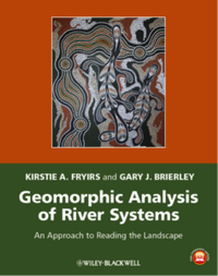 Fryirs KA, Brierley GA. 2013. Geomorphic Analysis of River Systems: An Approach to Reading the Landscape, First Edition. Blackwell Publishing Ltd.: Chichester, U.K.
To view through the library by Chapter:
- CHAPTER ONE: Geomorphic analysis of river systems: an approach to reading the landscape
- CHAPTER TWO: Key concepts in river geomorphology
- CHAPTER THREE: Catchment-scale controls on river geomorphology
- CHAPTER FOUR: Catchment hydrology
- CHAPTER FIVE: Impelling and resisting forces in river systems
- CHAPTER SIX: Sediment movement and deposition in river systems
- CHAPTER SEVEN: Channel geometry
- CHAPTER EIGHT: Instream geomorphic units
- CHAPTER NINE: Floodplain forms and processes
- CHAPTER TEN: River diversity
- CHAPTER ELEVEN: River behaviour
- CHAPTER TWELVE: River evolution
- CHAPTER THIRTEEN: Human impacts on river systems
- CHAPTER FOURTEEN: Sediment flux at the catchment scale: source-to-sink relationships
- CHAPTER FIFTEEN: The usefulness of river geomorphology: reading the landscape in practice
See also the Student Companion website for the book.
Brierley & Fryirs (2005) - Optional
 This is the "River-Styles" text book and is a helpful follow up reference (not required)
- 📄 PDF Brierley, G., and K. Fryirs 2005. Geomorphology and River Management: Applications of the River Styles Framework. Blackwell Publishing, Victoria, Australia.
Grade Scheme
The following grading standards will be used in this class:
| Grade | Range |
|---|---|
| A | 100 % to 93.0% |
| A- | < 93.0 % to 90.0% |
| B+ | < 90.0 % to 87.0% |
| B | < 87.0 % to 83.0% |
| B- | < 83.0 % to 80.0% |
| C+ | < 80.0 % to 77.0% |
| C | < 77.0 % to 73.0% |
| C- | < 73.0 % to 70.0% |
| D+ | < 70.0 % to 67.0% |
| D | < 67.0 % to 60.0% |
| F | < 59.0 % to 0.0% |
Library Services
All USU students attending classes in Logan, at our Regional Campuses, or online can access all databases, e-journals, and e-books regardless of location. Additionally, the library will mail printed books to students, at no charge to them. Students can also borrow books from any Utah academic library. Take advantage of all library services and learn more at libguides.usu.edu/rc. (Links to an external site.)
University Policies that Apply to this Class
Please visit the Canvas Syallabus page for upto date University Policies (e.g. for 2024).