Assignment
See Corresponding Assignment
Module 8 GUT Assignment
Background and why we're covering it
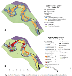
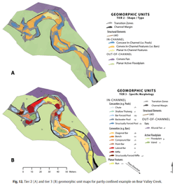 Geomorphic units are the building blocks of riverscapes and the first step to reading riverscapes. In this unit, we focus on those building blocks that make up the channel. Geomorphic units are also a convenient lens for discriminating fluvial habitats. We looked at the Wheaton et al. (2015) Fluvial Taxonomy for geomorphic units, which is an extension and recasting of geomorphic units as described in your book and the River Styles Framework. The taxonomy also describes structural elements and margins in riverscapes, but that is not the focus of this unit.
Learning Outcomes
- LO 1. Confidently read any riverscape and be able to map its core characteristics.
- LO 6. Appreciate that topography is a quantitative record of landforms and apply morphometric analysis can be used to map and differentiate those landforms (i.e., geomorphic units).
- LO 7. Gain an appreciation of how geomorphic processes of erosion, deposition transport and storage of sediment shape topography and create, maintain, sculpt and destroy distinctive landforms.
Resources
Part 1 - Intro
Lecture
⏱️ 30 minutes.
Slides
Slides
Lecture Slides - Module 8 (Part 1)
Part 1 - Intro
Part 2 - Book Description of Instream Geomorphic Units
Lecture
⏱️ 1 hour 5 minutes.
Slides
Slides

Lecture Slides - Module 8 (Part 2)
Part 2 - Instream Geomorphic Units (your book)
Part 3 - Fluvial Taxonomy
Lecture
⏱️ 1 hour 10 minutes.
Slides
Slides
Lecture Slides - Module 8 (Part 3)
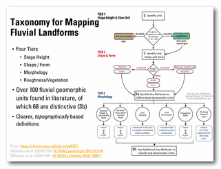
Part 3 - Fluvial Taxonomy
See Wheaton et al. (2015) Fluvial Taxonomy resources below.
Exercises to Complete During Part 3 of Lecture
If you want to print out just the exercises you can do so below. Note we only use exercise 3, 4 and 5 (no need to print all 7 pages). These are from a capstone crash course in fluvial geomorphology:
Exercises
Geomorphic Unit Exercises
Exercise Handout for Print
Other Resources
Field Trip Handout
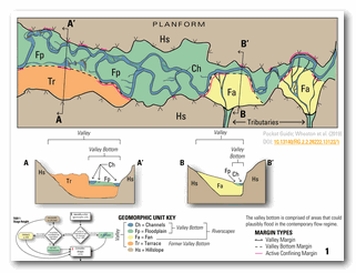 For our field trip, we visited the Logan River at Rendevous Park. For a PDF of handout, click below:
Field Trip Resources
Field Trip Handout
Print before going to field
Field Trip Album
Share your Field Trip Photos Here!
Some Tips when Mapping in Field
- Decide what tier of mapping is necessary for your purposes.
- Clear definition of minimum mapping unit in terms of multiple of bankfull width (e.g. 0.25 bfw or 1/3 bfw) for minimum length-scale of longest axis of unit. This helps avoid mapping every micro-habitat (hydraulic unit scale) unit like pocket pools and focus on broader picture). We discussed how this choice is necessarily problem specific (e.g. you might go finer-scale for some fish habitat work; coarser-scale for broader geomorphic interpretations)
- The fact that the taxonomy filters down your choices to 2 or 3 units at Tier 3 when applying one attribute at a time. The goal is not necessarily to get the absolute correct unit: but narrow down to possible candidates and sometimes units have a "complex" history and are truly a mix of different units. Sometimes it will obviously land on 1 unit, where it does not, don't fight it or force it. Just say it is "one of these two or three", or "most likely this one, but could be that one", or "a mix of these two".
- Instead of focusing on identifying units by polygons and identifying their boundaries, when identifying in the field go to their defining point or mid point. For example, the top of a bar (convexity) , the deepest part of a pool (concavity), the crest of a riffle, the middle of a boring planar reach. Just identify the point and worry less about the boundaries between the units.
Map for Field Trip Reaches
Geomorphic Unit Toolkit
Related Reading
This module focus on: CHAPTER EIGHT: Instream geomorphic units from:
- Fryirs KA, Brierley GA. 2013. Geomorphic Analysis of River Systems: An Approach to Reading the Landscape, First Edition. Blackwell Publishing Ltd.: Chichester, U.K.
2015 Fluvial Taxonomy
 📄 Wheaton J, Fryirs K, Brierley GJ, Bangen SG, Bouwes N, O’Brien G. 2015. Geomorphic Mapping and Taxonomy of Fluvial Landforms. Geomorphology 248 : 273–295. DOI: 10.1016/j.geomorph.2015.07.010
Williams RD, Bangen S, Gillies E, Kramer N, Moir H, Wheaton J. 2020. Let the river erode! Enabling lateral migration increases geomorphic unit diversity. Science of The Total Environment : 136817. DOI: 10.1016/j.scitotenv.2020.136817