Module 7 - Topographic Changes
See Corresponding Learning Module
Go to the learning module for this topic.
The Set-Up
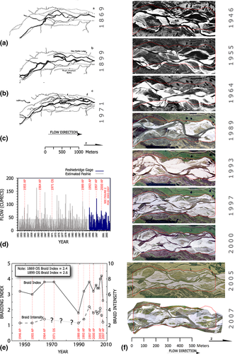
 We will take you to the Highlands of Scotland, to the River Feshie to help you become familiar with quantitative analysis of channel geometry changes (the subject of Chapter 6). In the figure at right from Wheaton et al. (2013) we can see a braided gravel bed river actively adjusting through time. You will be given access to topographic surveys from 2003, 2004, 2005, 2006 and 2007 of this reach.
In the book, your authors talk about bed and bank processes that influence channel shape. You will zoom in and look directly at such changes to a real river, and use a tool, the Geomorphic Change Detection Software to analyze it quantitatively.
Purpose
The goals of this assignment is to i) give you experience working with topographic datasets (that capture channel geometry), and ii) help you recognize and identify specific mechanisms of geomorphic change from repeat topographic datasets. These concepts were cast in Chapter 7 as "Channel Geometry" changes and here we will unpack that a little more with topographic analysis.
Prerequisites
Students/Participants are expected to have some previous GIS experience and some understanding of topographic data and digital elevation models.
There is a GCD Add-In for ESRI ArcPro that ArcPro users can download. If you don't have access to ESRI products, you can do this exercise using a standalone version of the GCD software. The standalone version lacks the built in map display provided by the add-in, however, it has all the same analysis capabilities, and the outputs can be visualized in QGIS.
The Assignment
Part 1 - Build Project & Do Some Budget Segregation
The videos below are a bit dated and demonstrate the ArcMap Add-In version of GCD. However, the workflows are the same in the ArcPro and standalone GCD software.
For the first part of this assignment, I want you to do:
- 1.A Download the Feshie Data (also below)
-
- B Create a GCD Project (you will bring this to class on Monday and turn this in for Part 2) with at least:
- 1.B.1: Three of the Five years loaded as surveys (see videos for how to do error modelling)
- 1.B.2: Two change detections (threshold @ 80% probability) for two of the epochs
- 1.B.3: A budget segregation with at least two examples each of the following mechanisms of change identified:
- Bank Erosion
- Channel Bed Lowering (degradation / incision)
- Channel Bed Rising (aggradation)
- Bar Development
As you work through this, post any questions and/or problems you encounter, or any potentially interesting findings to a class Discussion.
Concepts to Illustrate & Explain
Building your GCD Project. In this tutorial, I show you how to get through 1.B.1 and 1.B.2 above.
Doing Budget Segregation. In this tutorial, I show you how to get through 1.B.3 above.
For more information on budget segregation, see the following GCD Tutorials:
Part 2 - Turn in a Web Page
You will prepare a web page explaining what you did and defending your interpretations. Please include clear annotated figure(s) and/or video showing the identification two examples each of these four mechanisms:
- Bank Erosion
- Channel Bed Lowering (degradation / incision)
- Channel Bed Rising (aggradation)
- Bar Development
If you opt not to use video, please instead describe with text what you interpreted and justify your interpretation.
Resources
Dataset
River Feshie, Scotland, UK
A 700 m long braided reach. Dataset.
Dataset includes:
- 700m braided gravel bed river in the 📍 Scottish Cairngorm mountains
- 5 annual surveys
- Mix of RTKGPS and Total Station
- 1m cell resolution
Relevant Paper
The work we will do on "budget segregation" is based on Wheaton et al. (2013):
- Wheaton JM, Brasington J, Darby SE, Sear DA, Vericat D‡., and Kasprak A. 2013. Morphodynamic signatures of braiding mechanisms as expressed through change in sediment storage in a gravel-bed river. Journal of Geophysical Research - Earth Surface. DOI: 10.1002/jgrf.20060.
Album
Here is a Google Album of the Feshie to get a better feel for the site.
More Background on GCD
We have taught numerous courses and workshops on GCD. The following resources might be helpful if you want a deeper treatment of the methods and topics: